30 March 2006

Metaphor (poem)

Metaphor

she says everything’s a metaphor
for something else
rooster for dawn
dawn for the new day
the new day for beginnings
for a fresh start another chance
or what’s past endings

I see I say
it’s all progression
one thing to another
parallels and connections
metaphor as paradox
the distance fixed between
two connected things

but she says
it’s all a matter of perspective
and looks through me as if
I’m at the point of vanishing
the appearance of drawing closer
she says
is an illusion.


Words seem elusive, so here's another poem from a few years ago.

Photo: Looking South over Eastbourne towards the entrance to Wellington Harbour; rain drifting in. If you keep following that coast, you arrive eventually at Baring Head.


Photo and words © 2006 Pete McGregor

24 March 2006

Tales of white-tails

She caught my eye as soon as I walked into the kitchen. Perfect curves; long, slender legs. Poised; athletic. Utterly motionless, yet ready to sprint in an instant. I think what attracted me also was a frisson of danger—treat her without respect and she’d bite back, hurt you.

I found an empty container and encouraged her into it, closed the lid and placed the pottle on the table. She crept up the smooth sides and settled near the lid, apparently not overly disturbed. I left her resting quietly there.

The next day I photographed her, gently, trying not to alarm her. She was quick, though. Several times I had to fence her in as she ran for the edge of the table. Mostly, however, she cooperated, remaining motionless while I composed and focused. I began to grow fond of her.

Late in the afternoon I took her outside and watched her disappear into her new home among the timbers stacked under the lean-to by the shed. It’ll be a good home for her — plenty of places to rest safely, an abundance of food. My kitchen wasn’t really suitable and she would eventually have made her way to other parts of the house. As much as I liked her, I wasn’t ready to share my bed with her or let her get into my pants. I wonder what she was thinking as she left to explore her new home? Perhaps something like, “Typical bloody male — use you then show you the door.”

I hope she wasn’t thinking that.

...

New Zealand has two similar-looking species of white-tailed spiders: Lampona murina, the predominant (perhaps the only) species in the North Island, and L. cylindrata, found in parts of the South Island. Both were unintentionally introduced from Australia in the 19th century.

These spiders don’t build webs; instead, they roam, seeking prey in the form of other spiders. In New Zealand, they prey particularly on the grey house spider, Badumna longinqua, but will take other spiders. Years ago I saw a white-tail kill a grey house spider. I’d noticed the grey house spider crouched in its raggedy web outside the tunnel-like retreat, and I looked closer. Inside the retreat, I saw the front of another spider; enough to see it was a white-tail. Neither spider moved. I shifted a little closer for a better view, but the movement must have alarmed the house spider. It ran back towards its retreat, only to be seized in a flash by the white-tail. The sheer speed was astonishing, but what was more remarkable was the effect on the house spider. On being grabbed and presumably bitten, it must have died instantly. I never saw it move again, from the moment the white-tail captured it.

Ironically, white-tails occasionally fall prey to other spiders. I’ve seen a common daddy long-legs wrapping an unlucky whitetail in swathes of silk; when I returned later in the day, the white-tail was nothing more than a tightly wrapped bundle.

White-tailed spiders have had a bad press, here and in Australia, being blamed for sometimes horrific injuries—putative bites ulcerating, failing to heal, and causing extensive tissue damage which occasionally leads to amputations. The medical term for these injuries is necrotising arachnidism, and media coverage, often sensationalised, has led to a folklore that white-tailed spiders are dangerous and nasty. It’s common now for any substantial infection and necrosis resulting from a minor skin puncture to be attributed to a white-tailed spider bite, regardless of whether the spider was seen biting—or even seen at all. At the local climbing gym a couple of years ago, a young woman told me how she’d had a white-tail bite which had caused nasty symptoms. She hadn’t seen a spider, nor felt the initial wound, just noticed the rapidly spreading ulceration. Apparently, it was the doctor who treated her at the hospital who told her it was a white-tailed spider bite. He also told her the spider lays its eggs under your skin. There’s a word for that sort of information.

Studies in Australia and New Zealand suggest a very different picture, concluding that bites from white-tailed spiders rarely, if ever, cause necrotic ulcers. Moreover, if you are bitten, you’re likely to notice it and probably see the spider, as bites are typically painful—sometimes severely so. By far the most common consequence (other than the pain) is an itchy, reddened lump that lasts a week or two, but in roughly half the cases, this itchiness and swelling lasts only a few days at most.

You can find a good summary about white-tailed spiders in New Zealand, including the consequences of bites, on the Landcare Research page.


Photos 1 & 2: This is her. I forgot to get her vital statistics, but she would've been about 30 mm (±5 mm) from the tip of her front legs to the end of her abdomen.
Photo 2: This is the daddy long-legs, Pholcus phalangioides.

Photos and words © 2006 Pete McGregor

21 March 2006

Wellington: Dead or alive?

Most of the shops I’d wanted to visit in Wellington were closed. Well, two—Unity Books and Bivouac. Perhaps it was a good thing. I checked a few music stores, in all of which I failed to find Talking Timbuktu (and would probably have been unable to afford it anyway); I browsed Dymocks, unsure of which books I wanted to investigate; and I wandered into Mountain Designs to stare pointlessly at the shoes, thinking of the disintegrating Garmonts which had begun to cut into my heels. Faced with a wall arrayed with expensive footwear—all, I assume, made in China or a similar cheap-labour country at the cost of a few dollars and who knows how many workers’ health—I realised I don’t actually need most of the things I was ostensibly shopping for. Unmotivated and uninspired, I walked out and made my way towards Te Papa, the Museum of New Zealand.

I wasn’t sure why my feet took me there, not sure what I wanted to look at. Out of habit I walked up the stairs, across the foyer, into the Awesome Forces hall, and on towards the natural history exhibits. Someone with a little digicam was photographing the great, upraised foot of the enormous moa; above him, poised at the moment of impact, a huge Harpagornis stretched talons down to strike the moa. Nearby, a set of scales balanced three mice against a giant Deinacrida—3 blind mice, the equivalent of a dry weta. At the far end of the glass case I found reconstructions of two extinct birds: the long-billed wren (Dendroscansor decurvirostris) and the Stephens Island wren (Traversia lyalli). I crouched beside the case, reading the text. I’d thought the Stephens Island wren had been known from only a few specimens (that terrible word) brought in by the lighthouse keeper’s cat. Not so, apparently. According to the text, in 1894, Walter Buller looked at what the cat brought in and declared it a new species. Within two months, 15 specimens had been caught and sold to collectors.

No more were seen [1].

...

In the adjacent Mountains to Sea exhibition, a display showed some of the fauna and flora of the Southern Alps. A kea called from above and I recalled the last time I’d heard that sound, just a month ago above Lake Adelaide in the Darrans.

Then I found the rock wrens; male and female. Old and faded, their colours almost gone. Very still. Silent. They refused to look at me—so unlike the attentive, interested little lives I’d met at Sefton Biv, above Lake Adelaide, at Phil’s Biv, and on the yak pastures below Sabre. I moved around, but the female maintained a slightly downwards gaze, as if trying to remember something from long ago. I looked at her for a while, then left the building, walked out into the open where gulls flew and argued along the waterfront, where sparrows fossicked in the tussocks and shrubbery of a rock garden, and a pair of mallards swam out of the darkness into rippling light. I felt as if I’d been kicked in the chest.

What does it matter—what we do with things after they die?

(Click on the photos to get a larger image)


Notes:
1. Other accounts of the Stephens Island wren’s extinction exist. Perhaps the best researched is that of Galbreath & Brown (2004); the authors concluded that 14–17 birds were collected from 1894 until possibly as late as 1899, not all by the same cat. The outcome, of course, was the same. [Galbreath, R.; Brown, D. 2004. The tale of the lighthouse-keeper's cat: Discovery and extinction of the Stephens Island wren (Traversia lyalli). Notornis 51(4): 193-200. (Abstract)]

Photo 1: Detail from the Wellington waterfront: an extract from Denis Glover’s Wellington Harbour is a Laundry. Extracts from other poems, by other poets, have been incorporated into the waterfront’s architecture in ways like this. Poem as sculpture; words made concrete.
Photo 2: Dawn over Wellington Harbour, from where I was house sitting last weekend, high on the hills above Eastbourne. Central Wellington directly below the moon.

Photos and words © 2006 Pete McGregor

16 March 2006

Sabre: the Darrans

By evening the nor’wester’s in full force—howling wind; hogsbacks; dark cloud piled high and looming, obscuring the Main Divide and Mt Cook Range. Later, rain. I wake during the night and listen for a while to the wind and rain on the iron roof; that wonderful sound when you know you can sleep late and don’t have to be out in the weather. It’s warm and snug in my sleeping bag, but I keep thinking about Sefton Biv. I wonder where the wrens are, and what they’ll do in the rain when daylight arrives.

At dawn it’s still grim. Thwarted by the weather and conditions on the glaciers, which are broken up and shattered to the point of being impassable, we travel South, leaving the rain and hoping to meet the fine days following the front. By the time we reach Omarama, where we stop for lunch, we’re into sun and heat and arid countryside where limp trees rustle and shimmer in the hot breeze as they desiccate and shrivel. I get a pie and a horrible, syrupy, warm milkshake so dire we end up laughing as it goes in the bin. But, at Mossburn later in the day we find real fruit ice creams and wonderful entertainment from a friendly and cheerful woman with the distinctive, rolled-“r”, Southland accent.

“Stand back,” she says, laughing as she starts the machine to mash up my yoghurt and raspberries. We oblige, then sit outside eating, and wondering whether I’d misread the sign that said, “Mossburn: the Beer Capital of NZ.” (I had—it was “Deer Capital”.)

At Te Anau we check the forecast, shop for groceries, buy a map, and try to hire a mountain radio. Jonathan’s on the phone, trying to contact the radio man while I read the information sheet about hiring radios. I glance at a figure on the sheet, and suddenly it registers: 2 kg! These must be a different sort; those we usually carry are only about half a kg. However, we can’t hire one anyway, so we drive on, up the beautiful Eglinton Valley and over into the Hollyford. New country for me; legendary country.

At Gunn’s Camp an H-bomb hangs, nose up, fins down, squat and sinister, by the side of the road. On its black body someone’s painted a big radiation symbol and a warning: “no smoking”; but we’re reassured by the accompanying message in white paint: “Deactivated by the New Zealand Prime Minister”. Brilliant. It sets the tone of the place and as I wander about, enjoying the sight of little cabins roofed with battered corrugated iron, small birds flitting about, the signpost directing you everywhere—the camp office; Invercargill; the end of the road; heaven; upriver; downriver; Milford Sound; many local highlights—I realise everyone else seems full of the same infectious sense of goodwill and irreverence. In the evening we sit down to eat at one of the outside tables with the sandflies and clink beer bottles in a hopeful toast: “To Sabre!” and a Frenchman at the other table calls out, “Bon appetit!” and raises his tumbler of red wine to us. A woman with an Irish accent chats for a while until the sandflies drive her into her cabin, and an American woman looks at our enormous meals, laughs, and says, “Are you going to eat all that?”

“Just watch,” we say.

...

Jonathan lowers his pack at Phil’s Biv and rubs his shoulders. “That’s the hardest day’s tramping I’ve done in a very long time,” he says.
I’m so relieved to hear it. He’s as fit and strong as they come, and to hear he’s felt the effort is a kind of vindication; a justification that I’m not just a wuss; that it really was a hard day. I’m not exhausted—I’m shattered. My feet ache, my legs refuse to acknowledge instructions from my brain, the synovial fluid in my knees has turned to paste, and it takes ten minutes to turn my head because the muscles in my neck and shoulders have seized solid. We’ve walked for 9 ½ hours with 20–25 kg packs, over rough country, ascending well over a thousand metres overall; much more considering the downs and ups. From the outlet of Lake South America we saw what we assumed was Phil’s Biv, apparently just a short distance away. It took us an hour to get there; picking a route too low on the mountainside, we were forever climbing down into then up out of a near endless succession of narrow water courses, thrashing through scrubby ribbonwood and deep, dense snowgrass, stumbling over hidden rocks and into holes, and trying to avoid being perforated by the abundant speargrass. Diabolical.

But we’re here now, and the forecast for tomorrow is for rain. Good. We can rest: sleep, eat, recuperate, gather our strength. Cloud strays around The Sentinel, Apirana, Revelation, and the other peaks encircling us. Above the drifting mist, the sky’s overcast, and a couple of hundred metres below, in the dull evening light, Lake Adelaide gleams like polished zinc. After dark I switch off my headlamp and lie cocooned in my sleeping bag inside my bivvy bag, thinking about the rock wrens we’ve met on our way here. Thinking about a few grams of feathers and personality as I drift off to sleep beneath hundreds of tonnes of hard granite—the house sized boulder that forms Phil’s Biv.

A wren visits in the morning; a brief call to check us out and then he’s away doing his bird things. How many people has he met in his life? How many people noticed him?

The light planes and helicopters, which yesterday had constantly yowled and droned and hammered overhead on their scenic flights from Milford Sound, are today silent. Another reason to be grateful for the rain. Jono says it started about 1:30 a.m. and it’s continued, off and on, all morning, with a brief period when it began to clear before closing in again. During the afternoon, dense, dark cloud pours over Adelaide Saddle and fills the valley, eventually blotting out everything beyond the little, snowgrass-topped hummock in front of the biv and bringing heavy, continuous rain. Jono sleeps for a while; I sit, propped up in my bag near the entrance, reading. When the cloud begins to pull back I see yesterday’s route cut by many cascades—white water streaming and frothing in narrow torrents—and realise that walking out in the rain won’t be possible. Anything more than drizzle will cut us off.

A kea alights nearby, hops around, and sits for a while, hunched up and watching. I watch back, but I’m clearly boring and it flies off.

The day passes. After the rain stops, Jono reconnoitres the route to the bluffs leading to the “yak pastures” and the foot of the climb; he returns, bringing the good news that the access seems less scary than it appears from a distance. Meanwhile, I’ve stayed put, giving my troublesome knee as much chance as possible to recover. At dusk, a big tongue of mist licks down from the cloud above Lake South America, swirls, and disperses; and the roar of the falls below the lake swells, then fades as the wind eddies. Two words come to mind: Wild, and Uncompromising.

...

Back at Phil’s Biv after an attempt that was more a reconnoitre than a climb, and the irony—and frustration—is that it’s a beautiful evening. We reached the hardened remains of the snowfield that stretched down from the col below Sabre’s East ridge, with cold, dark cloud swirling and enveloping the upper half of the mountain; there, Jonathan painstakingly hacked rudimentary steps up the icy snow to the col, but could see nothing. I followed a short way, enlarging the steps before realising it was futile and instead huddling at the foot of the ice with our packs, trying to stay warm. From time to time, feathers of clear, fragile ice floated down out of the cloud, sometimes fracturing in mid fall, sometimes shattering on the rocks below. I assumed they’d been set free from the almost sheer rock wall. We’d wanted to climb that. I studied what I could see of it, and eventually noticed two slings suspended on the precipice, one above the other, about a rope length apart. The thought that someone had been up there seemed reassuring—but slings left on a mountainside suggest someone’s abseiled off. Perhaps the climbers who’d left these had found the route too hard, perhaps too psychologically daunting. It looked daunting to me, in these conditions, yet this wall towering above me and disappearing into darkness had been climbed many times, by at least 8 routes, some comfortably within our technical ability.

But not today. Jono returned and we descended delightful granite slabs to a level shelf where someone had camped. Against a small wall of rocks we found a cairn, and under it an old haul bag containing a rope, pitons, rock drills and other paraphernalia. After inspecting it we bundled it up securely and repacked it beneath the cairn, then ate lunch while sheltering from the wind. Below us, small, steep, alpine meadows —the yak pastures (but without yaks)—dropped down to the access bluffs; below those, the head of the cirque sloped down to Lake Adelaide. It seemed tremendously far below.

On the lower yak pastures we met a pair of rock wrens.

...

It’s our last night at Phil’s Biv. I think of its history; in particular, its name. Phil Herron, a young climber described by Hugh Logan in Classic Peaks of New Zealand as “...a bright young star, travelling the knife edge between larceny and fierce high spiritedness”, teamed up with Bill Denz and Murray Judge to make first ascents of several ground-breaking routes here on Sabre and Marian in the mid ‘70s. Soon after, during an attempt on Torre Egger in Patagonia, he fell into a crevasse. He died there, 30 years ago. Phil’s Biv was named in his honour; at Baring Head the wall with the hardest bouldering routes, the Only the Good Die Young wall, is a tribute to him; and in Patagonia, a peak in the Cerro Torre group bears his name: Punta Herron. First climbed in March 1980, it received only its 5th ascent last year (2005).

Outside, the last light’s vanishing and brilliant stars brighten in an infinite sky. To climb mountains you must take risks, and sometimes luck chooses a different route. It did for Phil Herron and Bill Denz. Was it worth it? Did they “lose”? I can’t make those judgements for others, only for myself, and I can’t imagine ever taking the kinds of risks they did—I’m too scared! Besides, there’s too much to live for, too much I want to do and see—too many mountains I want to climb. And, if you avoid risks, you never really live.


(Click on this photo for a larger image)


Photo 1: The view from Phil’s Biv: Lake Adelaide and the head of Moraine Creek, in the Darrans.
Photo 2: Lunch stop in Moraine Creek, on the walk in to Phil’s Biv.
Photo 3: This was where we were heading. Sabre on the left, partly obscured by cloud; Marian on the right.
Photo 4: You should know her by now—piwauwau, the rock wren, Xenicus gilviventris. She came to check us out in the boulder fields further up the valley.
Photo 5: Jonathan prepares to cut his way up to the col to look at the mist.
Photo 6: Lake Adelaide from Sabre. The buttress on the left is what we’d hoped to climb.
Photo 7: The cirque at the head of Moraine Creek. Lake South America drains into Lake Adelaide; above the former, The Sentinel disappears into cloud; on the extreme left of the snowgrass slopes, you can’t quite see Phil’s Biv. The lens has flattened the slopes—they’re steeper than they appear in the photo.
Photo 8: What we left behind at Aoraki Mt Cook—a nor’wester over the Tasman Valley and Liebig Range. You must click on this to appreciate it fully.

Photos and words © 2006 Pete McGregor


13 March 2006

Birds; beaches (and a poem)

The evolution of truth

Harry draws stick birds in the sand
and asks where do birds come from
so I tell him eggs
birds come from eggs
and of course he says
where do eggs come from
and we make it a game until he draws
a stick bird's egg in the sand
and says no really so I tell him
dinosaurs

so he draws in the sand
something with teeth
and looks down the beach
at the terns staring at their feet
listens to the big blackback yelping
a solitary flight into the grey wind
while I wait hoping like hell he won't ask
where he came from
and wondering if he does
whether I should tell him

dinosaurs.


I wrote this a couple of years ago. That's all I'll say about it.

Photo: Catlins beach; February 2006. No blackbacked gulls; not sure about the dinosaurs. (Click on it to get a larger image).

Photo and words © 2006 Pete McGregor

08 March 2006

In the Catlins

After leaving the Darran Range and Gunn's Camp (I'll tell you about that later), I left Jonathan at a mate's place in Dunedin for the weekend and headed South. Here are some impressions; here also, as promised, are a few more photos of fluffy little birds (as usual, click on the photos for a larger view).


Sometime before dawn, in that half light when night and day still struggle, I got up, ate breakfast and drove off; drove South on empty roads from Kaka Point into the Catlins. Mist filled the valleys and hollows, a diffuse fog with hazy boundaries, softening silhouettes, muting colours. I stopped, took a couple of photos, carried on; stopped again to photograph the old sheds filled with hay and machinery by the Owaka intersection. The sun had burned away most of the fog; the early morning light, now direct and unfiltered but still low and warm, accentuated colours and picked out details like the long, dry grass in front of a dark, doorless opening; the hard angles of an arcane farm implement; the texture of old corrugated iron, paint faded and peeling. Despite their air of age and abandonment, of countless stories and enormous possibility, the sheds projected authenticity—these were sheds in use, even if the use was infrequent.

Later that morning I drove past an older, wooden barn standing, prominent and obvious, boards broken and weathered, near the roadside. At first glance it seemed full of character, but as I drove past I realised it seemed too full of character, as if it had been left there deliberately so tourists could photograph it and exclaim, “What a wonderful old barn!” It seemed too much a statement; something left on purpose to add a complementary human element to the landscape. In a moment, my impression went from appreciation to dissatisfaction—this barn lacked the authenticity of the sheds I’d photographed earlier.

Of course, the facts are likely to be completely at odds with my impressions, and this barn might still be used for some genuine farming purpose, even if simply storing hay; and I’m sure its owner hasn’t left it standing primarily—or even at all—as something for tourists to appreciate. These were simply my impressions.

I began to wonder whether authenticity—something valued so greatly by so many people, perhaps especially tourists and travellers—is mainly a function of purpose. A shed used to support the farm, or other way of life of its owner, has an authenticity far greater than an otherwise functionless shed left standing because tourists like the look of it. At the other extreme, a shed built last year and designed impeccably for its purpose (storing equipment; shearing; workshop, etc.) may be totally functional but is largely devoid of interest—“character”, I suppose—until it has accumulated enough age and stories; until it has gathered enough dust and clutter to hide at least a few interesting things.

Perhaps you might dismiss what I’m saying as just semantics—you might argue I’m just defining words like “authenticity”, “purpose”, and “function” to suit my argument. But I don’t think I am; I’m not trying to argue a point, what I’m trying to do is explore an idea, a concept that seems real to me. Unfortunately, this requires words, and the words most useful for this already have their own meanings; meanings that differ, subtly or substantially, for everyone who uses them. This is the weakness of words. It’s also their power.

...

Further along the coast I stopped briefly at the Florence Hill lookout, to be instantly swarmed over by sandflies [1], so I continued South to Curio Bay. About once every half an hour or so, another car drove past going North; otherwise, for the first couple of hours I had the whole of the Catlins to myself—so it seemed. The crowds hadn’t arrived at Curio Bay, but by the time I left, a few people had drifted in, wandered about briefly, then left. No one seemed to take much time to feel the place, touch the land; everyone seemed to do no more than look. Briefly.

I cruised slowly to Slope Point [2]. Several cars and campervans had already arrived, but by the time I’d organised myself, some had left, leaving me feeling relaxed and uncrowded. Then four cars arrived in convoy, and 8 people got out. They walked in pairs, side by side, like a small platoon; marched to the Lighthouse, peered over the edge of the cliff, and took turns photographing each other standing next to or leaning over the sign—“Equator: 5140 km” pointing North, “South Pole: 4803 km” pointing South. Having done Slope Point, they marched back to the cars.

I sat for a while on a small shelf just down from the edge, sometimes looking at the silhouette of Rakiura (Stewart Island)—the first time I could recall seeing it clearly—but mostly thinking about the sea, and about sitting as far South as I could go on the South Island. I’d felt something similar years ago on the Surville Cliffs, the northernmost part of the North Island. No more New Zealand out there. Now, looking South, save for a few small islands, there was nothing between me and Antarctica. Out there, only sea—the great Southern Ocean; icebergs; wild light on albatross wings; petrels; penguins; fewer and fewer whales. A vast ocean, teeming with life, much of it still unknown, most of it alien to me. Beautiful, strange—and sometimes terrifying. Below me, a deep swell rolled in, heaved and burst against the rock platform—a huge roar, an explosion of white foam, bull kelp [3] writhing and flailing.

The sea. Where we all came from. The mother of us all.


Notes:
1. They're known elsewhere in the world as blackflies (Simuliidae). All New Zealand species belong to the genus Austrosimulium.
2. The hyperlink to Slope Point shows you where it is, but incorrectly states it's in Akaroa County (according to the site, everywhere in NZ is in Akaroa County, or in a place called "None". Yeah, right). In fact, Slope Point is in the Southland Region (here's some info about Southland's coastal environment).
3. Durvillea antarctica.

Photo 1:
Female ngirungiru (miromiro in the North Island), the tomtit (Petroica macrocephala); Arthur's Pass.
Photo 2:
Male rock wren, piwauwau (Xenicus gilviventris), near Sefton Biv.
Photo 3: Titipounamu, the rifleman (Acanthisitta chloris), gleaning at Arthur's Pass.
Photo 4: Jonathan browsing the hut book at Sefton Biv...
Photo 5: ... and resting in the afternoon sun; the tail of the Mt Cook Range in the distance .
Photo 6: This is usually not the weather you want to see in the mountains. Evening light on the Mt Cook and Liebig Ranges, from Sefton Biv.

Photos and words © 2006 Pete McGregor

07 March 2006

Listen to the land

We drove through central Otago in the heat, under grey cloud, surrounded by arid, brown-grey plains and hard, rock-knuckled hills; through the Kawerau Gorge; through a land of thorny weeds and desiccated grass, dust and rabbits, rows of windbreak pines on the other side of decrepit wire fences. I saw the way the light faded under those trees: among those pines, in their dim places, bad things might happen: a hitchhiker might disappear, the only trace a discarded jersey or solitary shoe. Places with mysteries that remain unsolved; places that enter NZ history and folklore and, eventually, mythology. Yet, despite the sense of foreboding, the land didn't feel evil: just sad, old, and irredeemable.

I think it was the light.

Everywhere, the land seemed to hold stories. I watched it pass by as I drove and thought, if I’d been alone I’d have stopped, walked away from the car and listened for a long time. It’s the land of poets and listeners and people who say nothing.

We were driving to Te Anau, and the Eglinton Valley, and the Darrans: places I’d never been; places—the Darrans especially—I’ve known since childhood. On to Lake Adelaide and the hard granite of Sabre.

I drove on, feeling as I were driving forward into my own history.


Photo 1: Enough of fluffy photos of little birds! Here's something entirely different; it's my neighbour's mailbox, back here in the Pohangina Valley, photographed two days ago—the same evening I took the background photo for the blog header (that was almost from my back door). More little fluffy birds coming soon...

Photo and words © 2006 Pete McGregor

02 March 2006

Climbing Rolleston

Early afternoon on Friday 3 February. The summit of Mt Rolleston [1] is enveloped in mist; it’s calm, mild, and the rock’s warm. From far below, the faint sound of water falling over rock drifts up through a quiet world.

It’s taken us about five hours from the car: up the Otira Valley to the foot of the Slide, where we’d strapped crampons to boots, then climbed the steep, rock and boulder strewn snow, occasionally scrambling awkwardly over rock to bypass ‘schrunds 
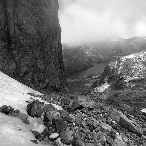
[2] where the shrinking snowfield’s pulled away from the mountainside. Earlier in the season this would be just a long plod but now the underlying rock has begun to emerge, in places separating the snow slope. Higher up the Slide, we removed our crampons and climbed as much as possible on solid rock, from time to time struggling up loose scree—“swimming,” Jonathan calls it—until finally we reached Goldney Ridge. There, perched on a giant, flat-topped, level rock the size of a small room, we ate lunch and admired the views: loose rock, solid rock, a glimpse of old snow, and beyond a hundred metres or so in every direction, nothing but mist. For a few minutes, the cloud below us thinned, treating us to a view of the head of the Bealey Valley and its small, nondescript glacier. Then it closed in again.

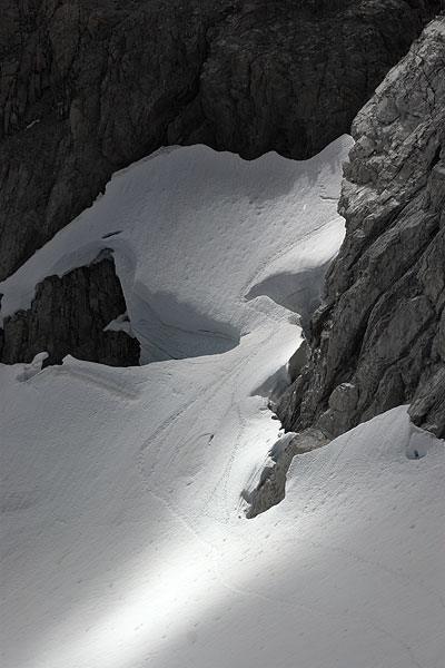
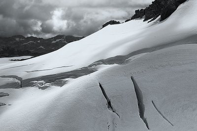
We climbed to the Low Peak, still cocooned in cloud. I felt worn out and weary but wasn’t about to call it quits. Crevasses on the Crow névé [3] —the easy route—cut off the Middle and High Peaks, but we negotiated the summit ridge with no real problems: just one or two slightly exposed sections a few moves long, with the awareness of a long fall below—a little nervewracking but not scary enough to encourage thoughts of roping up. And, despite my tiredness, I enjoyed the scrambling; enjoyed the feel of climbing, using hands and feet and balance, sometimes crossing one foot behind and over the other in a movement resembling yoga or a dance—joy in the feeling of controlled, deliberate, graceful movement, accentuated by its purpose. This wasn’t a mere trudge with effort as the primary, or only, requirement; this required skill, finesse, coordination.

It’s good to be here, even if we can see little from the summit. The climb hasn’t been technical, but there’s still that sense of achievement, and, most importantly, we know we’ll be able to descend the straightforward way if we return to climb the Otira Face of the mountain. All we need is reasonable weather.

We reverse the moves along the ridge to the Low Peak and descend the upper section of Goldney Ridge, down loose scree and short outcrops of sound rock. In places, it’s as if the bones of the mountain have emerged, the disintegrating cover of blocky rubble falling from an underlying, hard skeleton. The cloud’s closing in, releasing its rain—just enough to wet the rock. We check the route carefully in the restricted visibility, aware of the bluffs all around and not wishing to face a climb back up to retrace our steps. After some tentative exploration, we find an old abseil anchor; Jonathan sees a cairn across the gully, and we traverse across, finding an easy way down to the top of the Slide. It’s crampons again, and the long, knee-straining descent to the head of the Valley. Nine and half hours after leaving the car, we’re back there, just ahead of a torrential downpour. Great timing—and a great day.

...

We returned to the Otira Valley the next day to look for the sunglasses I’d left sitting on a rock near the terminus of the glacier. Several parties had already made their way partway up the track, and as we approached the head of the valley we met an elderly man accompanied by a gentle, quietly spoken, younger man. They were returning from somewhere higher, somewhere on the ridge—I don’t know which ridge they referred to, but they must have started early. I asked if they’d noticed any sunglasses.

“Yes,” the younger man said, and immediately began retrieving them from his pack, assuming without question that they must be mine. They were, and I felt slightly sorry to disappoint him—he must have thought it was his lucky day. The older man seemed reluctant to join the conversation, but when I addressed him directly, he began explaining how much he loved being in this environment; how, in the past, he’d climbed Rolleston innumerable times, with many people—here he mentioned legendary New Zealand climbers like Lynn Crawford—and how it didn’t matter to him whether he reached the summit or not.

“The journey is the destination,” I suggested.

He nodded, deliberately, recognising the truth of it. “The journey is the destination,” he said.

...

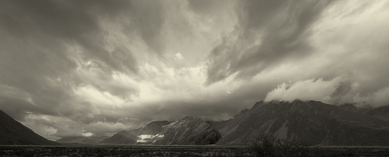
Morning: not a cloud in the sky; brilliantly fine weather with a chill to it; perfect for the Central Direct route on the Otira Face of Rolleston. 
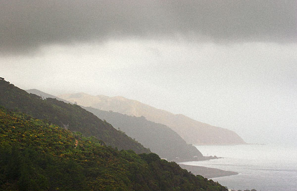
We’re up at 6:30, away at 7:45 and walking up the track by 8 a.m., right on schedule, with sun lighting up the head of the Otira valley. But, by the time we stop at the footbridge to shed jackets, our beautiful day has begun to deteriorate; cloud encroaches over Temple Basin and Phipps and streamers of mist flow up from the Bealey, over the Pass and down towards the Otira gorge. We carry on. As the Face comes into view we see the buttress remains free of cloud for most of its height but the uppermost section and the summit have been obliterated by a shifting veil of grey, drizzly cloud. The southerly front the forecasters had said would pass through overnight hasn’t: this is it arriving.

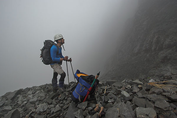
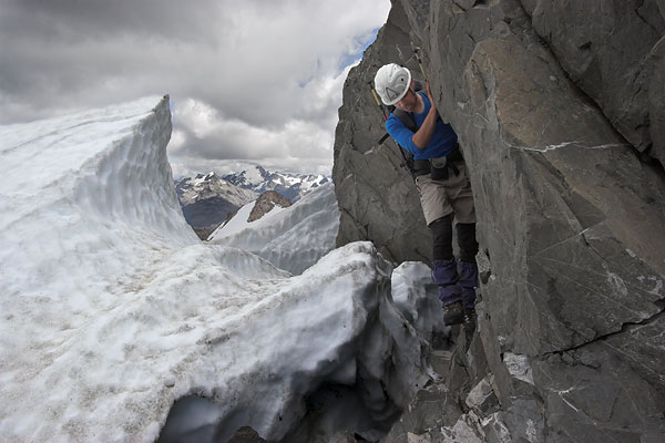
We decide to press on and at least reconnoitre the approach to the climb, assuming we’ll be back tomorrow after the front’s gone. By the time we’re climbing the tedious, blocky scree to the bluffs, drizzle has begun to wet the rock and any prospect of a successful climb fades as the world darkens. We ascend a short, near-vertical gut, partly solid rock, partly soil and moss and tiny, tough plants, and walk up rough slabs to peer into the gulch that provides the usual access to the buttress. In the dull, heavy light and oppressive mist it’s an evil-looking place. The top remains hidden, curving out of sight behind vertical rock and disappearing into cloud. It looks to be an awkward scramble to reach a ramp of old snow we hope will take us out onto the snowfield below the buttress.

Light rain has darkened rock and scree; it gleams, slick in the dull light. I shiver; having stopped to discuss what to do, I’m cooling rapidly. I’m inclined to call it a day, as going higher will achieve little but require a substantial effort the weather’s unlikely to improve. Jonathan agrees, so we downclimb the mossy gut in the wet and begin the tedious scree-hopping back down the valley.

...

The novelty of pasta or couscous had begun to wear off. We needed something fresher for dinner, but the only vegetables at the store at Arthur’s Pass were in cans—there wasn’t an onion in sight. Perhaps Otira might have something, and it’ll be a nice drive; spectacular and not too far. At the Otira hotel we walked past the verandah where a collection of locals leaned over the rail or lounged about, drinks in hand, watching us curiously as we headed for the tearooms, a small annexe to the pub. I nodded to them, said hi, feeling as if I’d been teleported deep into the Appalachians and half expecting to hear a banjo start up. Inside the shop, the owner, not just of the tearooms and pub, but the entire town, appeared behind the counter. We’d already discovered there were no vegetables.


“We’re on the hunt for vegetables,” I said. “In particular, an onion or two.”

“Hmm..., vegetables, eh?” He stood there looking slightly puzzled, as if trying to recall what a vegetable was and whether it might be a brand of beer. I asked him where the closest place might be where we could buy some vegetables. He thought for a long time.

“Well,” he said at last, “I’d say the closest would be either Greymouth or Hokitika!”

We thanked him and started to leave, having no intention of driving hours for an onion. He came out from behind the counter and followed us, clearly intrigued by the idea of vegetables.

“I could fix you up with a can of peas?” he offered, but it wasn’t really what we were looking for.

We walked back to the car, past the lined-up locals on the verandah. They seem to have relaxed a little, and even smiled at us; in a rush of goodwill, I almost joined them for a beer. Almost.

Dinner that evening wasn’t memorable—I can’t remember it.

...

Waitangi Day, 6 February 2006. Two hours after leaving the car we’re back at the foot of the Face, looking at the access gully. After yesterday’s rain, the snow ramp has collapsed, making the gut an even more dubious prospect. However, the alternative—the bluff to the left; near vertical, hung with mossy vegetation and running with water—looks even less appealing, so we explore the gully. Where the snow begins, so do the difficulties. Jonathan investigates the gap where the ramp has melted away from the sheer rock wall, while I strap crampons on and climb uneasily up the steep, hard snow, aware of how the middle section had collapsed within the last 24 hours and wondering how close it might be to collapsing further under my weight. I try to weigh less.

Neither route proves acceptably safe, so I check the rock on the other side of the ramp but quickly back off and we agree: the bluff is the only feasible option—one that leaves me with a sinking feeling. Probably fear.

By the time I’ve packed away my crampons, Jono’s out of sight, picking a way up through the bluffs. I follow, all too aware I can’t afford a single slip; that a moment off balance could prove irrecoverable. The only positive thing is the moss—in fact, it’s a tough, matted mixture of small, gnarly, subalpine plants clinging tenaciously to the rock; where thick enough, it provides a brilliantly solid placement for the pick of my iceaxe. Otherwise it’s horrible—a scary scamble which we later agree is probably the crux of the entire climb. I whimper my way up, not sure whether to be grateful to Jono for leading the way or to curse him for not giving up.

The rewards are relief when I can finally walk upright without needing my hands, and the spectacular sense of height and airiness. Already the Otira Valley seems enormously far below and the world’s a wild jumble of peaks receding to the blue-hazed horizon. The buttress looms above us, ascending into deep blue sky; the summit’s out of sight. Here, where we can move about freely, we put harnesses on and I arrange the rack—a few slings, a selection of nuts and carabiners. Jono leaves the rope at the top of his pack, quickly accessible. I wonder where we’ll need it; apparently most parties rope up for at least one pitch, but nothing we can see above looks too serious and it’s far faster to climb unroped.

In fact, much of the lower part of the climb is the solid, “warm, red sandstone” we’ve expected. It’s a joy to clamber over, but higher up, patches of looser rock require each hold to be tested. None of the climbing is particularly technical and the rope stays in Jonathan’s pack, despite occasional sections where, looking down, I realise a slip would send me bouncing to the bottom of the face. But, for the most part, the holds are good and the route keeps opening up.

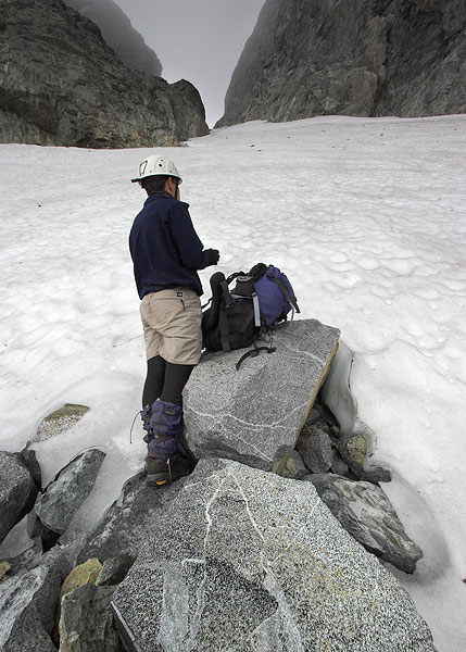
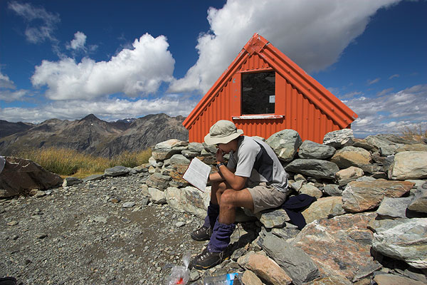
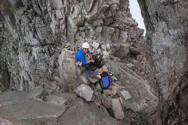
At one o’clock we reach a tiny saddle in a narrow section of the ridge. It’s an hour and a half from the foot of the buttress and a perfect place for lunch; somewhere we can sit and place our packs; move around carefully and take a few photos. I peer over into the gully on the western side and feel the slight off-balance sense of incipient vertigo. It’s a long way down, and you wouldn’t hit much on the way. Backing off, I look up at the ridge above us. It’s narrow and steep and appears a far more serious proposition; perhaps somewhere up there we’ll find the pitch where we’ll rope up.

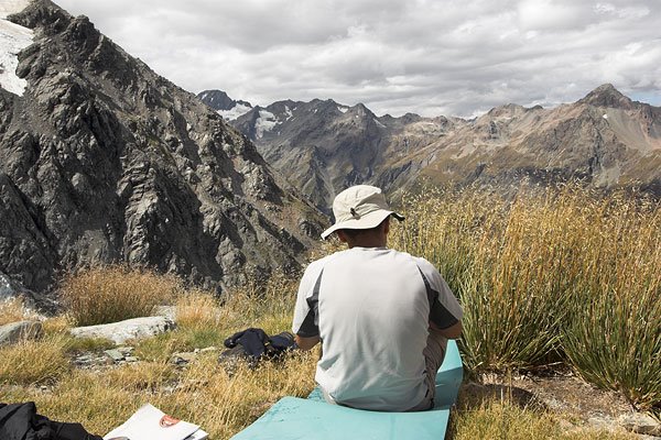
In fact, it’s not as bad as it looks. The climbing seems easier and mostly less exposed, but perhaps I’m distracted by my delight in the amazing views—the Otira Valley so far below; the head of the Waimakariri with the col leading to the Rolleston River; everywhere, mountains tinged with the purple-blue haze of great distance. Grey and white clouds laze in the sky, scattered about above the land, drifting their shadows over valleys, mountainsides, ridges, snowfields. The final section of the climb is on good rock, steep but without the nerve-tingling exposure of some lower sections. At 2 p.m. we reach the summit.

There’s no wind, just a sporadic breeze. We stay for an hour, nibbling snacks, taking photos, watching the light. I feel as if I could stay here for the rest of the day—I don’t want to miss anything; want to savour as much of this as possible. I give one of the rocks an appreciative pat and thank Rolleston for allowing us the climb. I mean it. By the time we get back to the car we’ll have traversed the upper Otira Valley eight times in the last five days: as Jonathan jokes, “we’ll be grizzled veterans of the Otira Valley”. Well, perhaps a little overstatement there... but we’ve certainly come to know it well; it feels familiar; when I return in the unforseeable future it’ll have an element of homecoming.

But, I wonder... perhaps coming to know a place—mountains, coast, sea, hills, all of those and more—is only part of a story; the story of a relationship, an interaction. Perhaps the other part of that story is allowing time for the place to begin to understand you.


Notes:
1. Mt Rolleston is the dominant peak near the township of Arthur's Pass.
2. "Schrund" is a contraction of "bergschrund", the crevasse-like gap where a glacier or snowfield has pulled away from the rock.
3. A névé is the uppermost section of a glacier.


Photo 1: Jonathan inspects the approach gully on our first reconnoitre of the Otira Face.
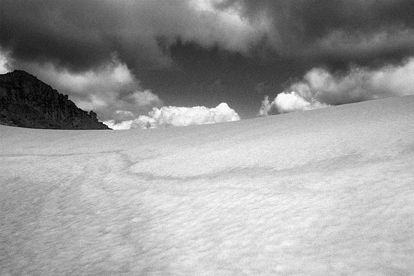
Photo 2: Snow saddle on the summit ridge of Rolleston.

Photo 3: Our lunch spot partway up the Otira Face.
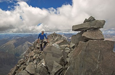
Photo 4: The summit, looking East.
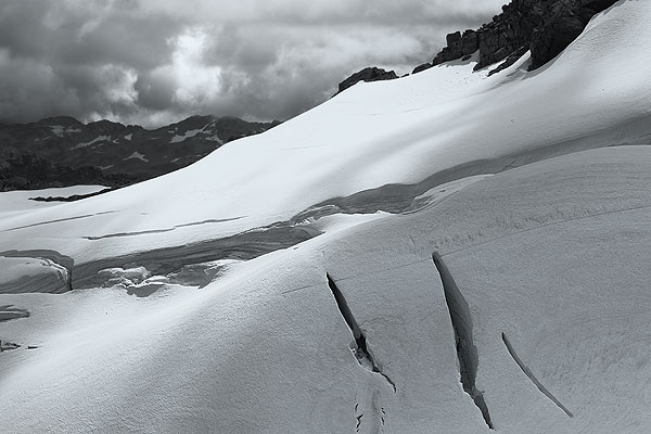
Photo 5: Crevasses on the Crow névé.
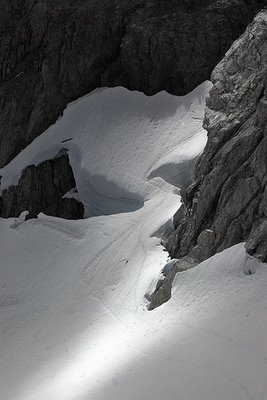
Photo 6: Crow névé schrund, below the summit.
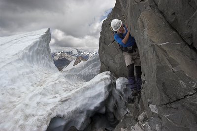
Photo 7: Jono negotiates the schrund on our way to the Low Peak.
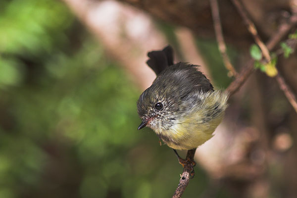
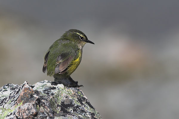
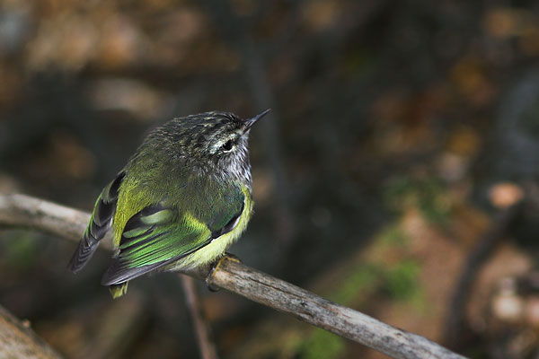
Photo 8: This, as promised, is the rifleman, titipounamu, Acanthisitta chloris. A pair of these tiny birds entertained us at the NZ Alpine Club Lodge in Arthur's Pass township.

Photos and words © 2006 Pete McGregor